Listening to the Cracking of the Ice Logbook TransTiP - Part 8: Searching for Clues in the Glacier Landscape
Scientists at the international DFG Research Training Group TransTiP are searching for hidden ice at an altitude of over 5,500 metres. A work under extreme conditions, since the air is even poorer in oxygen than at Nam Co. Dr. Matthias Bücker, Johannes Buckel, Dr. Nicole Börner, Kim J. Krahn and Alexandra Müller from the Institute of Geosystems and Bioindication complete the TransTip logbook with their eighth and last contribution.
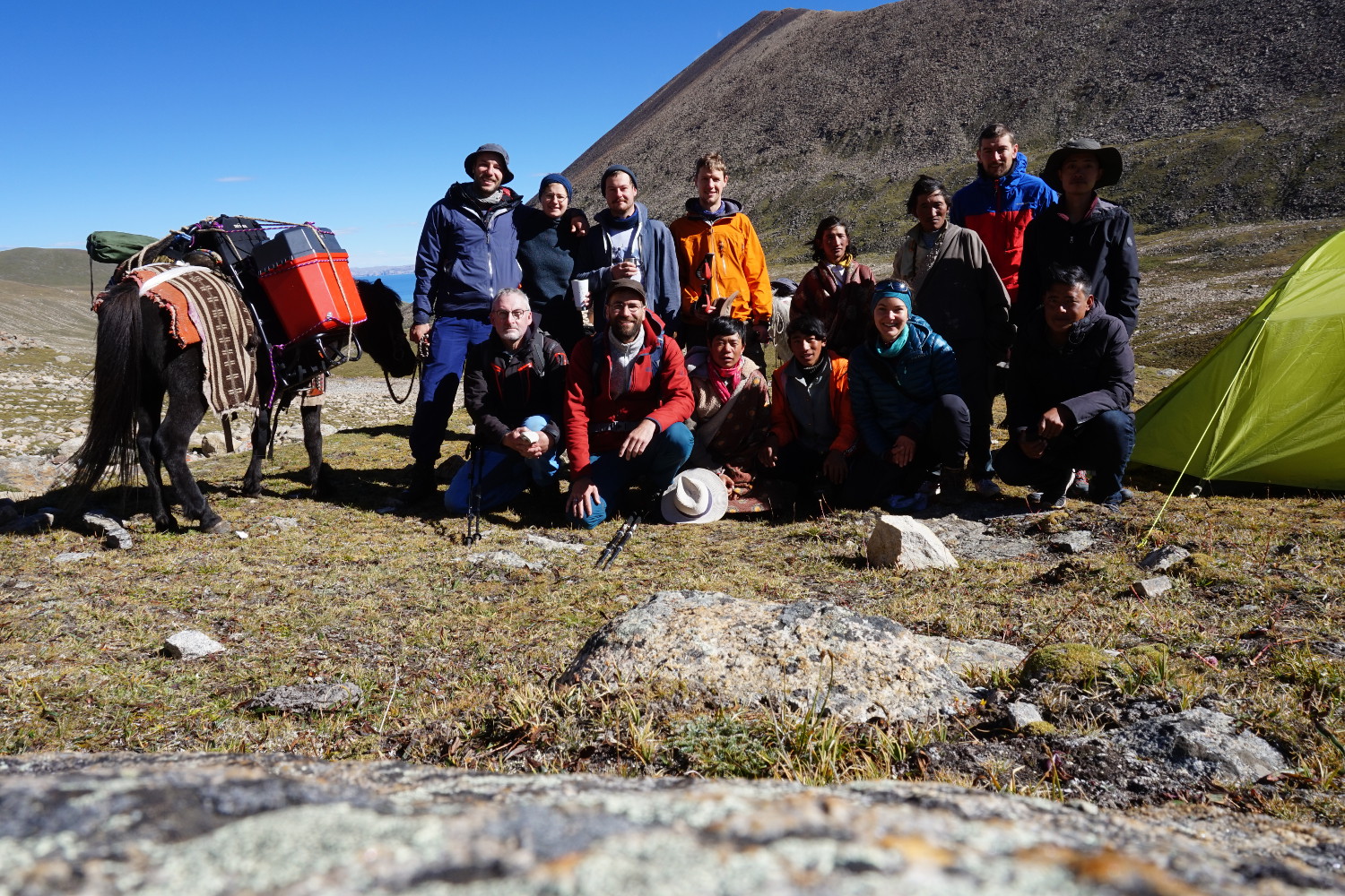
The team at lofty heights: (back, from left to right) Felix Nieberding (TU Braunschweig), Anne Voigtländer (GFZ), Ruben Schroeckh, Eike Reinosch, Johannes Buckel (TU Braunschweig), (from left) Dr. Björn Riedel, Dr. Matthias Bücker (TU Braunschweig), Nora Krebs (GFZ) together with colleagues from the Institute of Tibetan Plateau Research and the local Tibetans. Picture
credits: Johannes Buckel/TU Braunschweig
“In the mountains of the Nyainqêntanglha range in the south of Nam Co, some of which are over 7,0000 metres high, we encounter a landscape formed by glaciers and ice. Here is the difficultly accessible area of another group of our doctoral students. For their research, they advance to altitudes of over 5,500 metres. Here they use geophysical instruments and high-precision surveying techniques to search for underground ice and permafrost conditions. A search for clues that will explain the origin of this rough mountain landscape. Below the mountain peaks, ice masses hang on steep rock faces and glaciers lie in the valleys.
In Search of the Hidden Ice
Due to the continuing warming of the climate – which does not stop at the icy heights of the Nyainqêntanglha Mountains – today the glaciers have melted back a long way. However, the landscape they leave behind is far from ice-free. Both the analysis of satellite data and the presence of certain characteristic landforms in the high valleys of their study area gave doctoral students Eike Reinosch and Johannes Buckel early indications that in many places there must be larger amounts of ice underground. Supported by a highly motivated team, the two scientists have therefore decided to prove their assumption with measurements on site. They hope that their results will not only make an important contribution to understanding landscape development, but also provide insight into the formation and transport of sediments towards Nam Co. They also want to investigate how the existing ice contributes to its water balance.
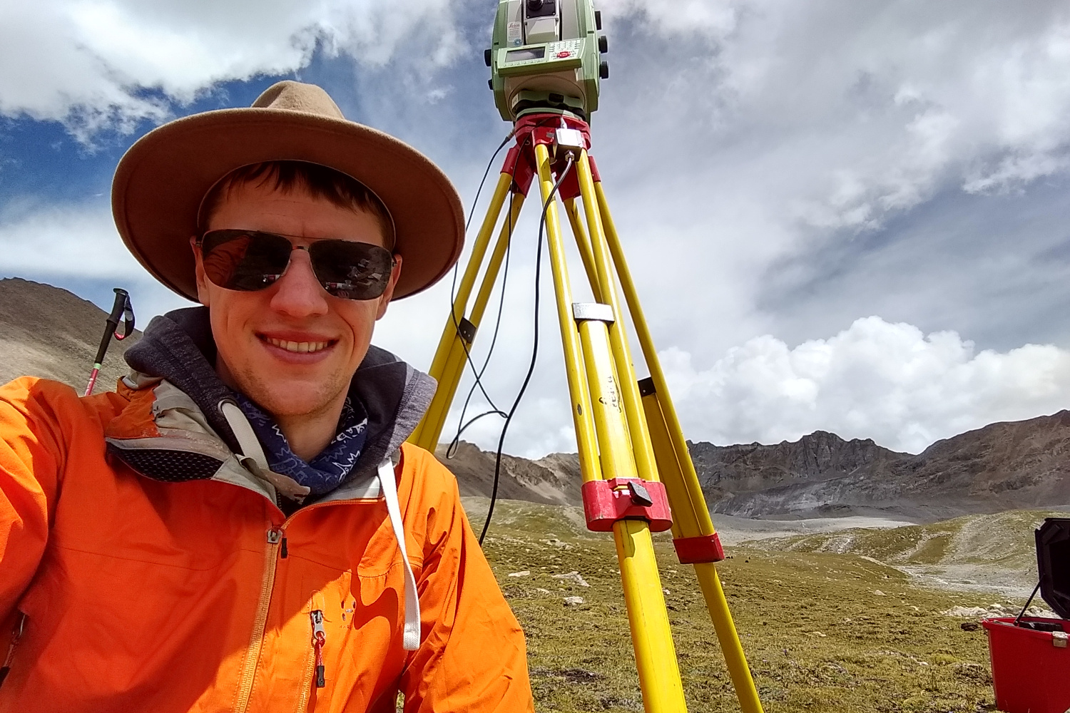
After installing the tachymeter, Eike Reinosch finally has time for a short breather, since the device fortunately takes up to 30 minutes to measure the terrain with millimetre accuracy. After that, he sets out for the next measuring point, carrying several kilos of equipment on his back. Picture credits: Eike Reinosch/TU Braunschweig
Vision aid for the eye in space
How can a satellite detect ice in the ground? Can you see from space what you can’t even see on the ground with the naked eye? No, of course not – or at least only via a detour: As you can already see on the glaciers, ice is not as solid as stone, but flows – very slowly but noticeably. This slow movement of a few centimetres per year was detected by Eike by comparing satellite images taken at different points in time – not only on the glaciers in the study area, but also on some rubblecovered slopes and elevations. In order to check the ground motion rates derived from the satellite data, he and Dr. Björn Riedel used a laser scanner and other high-precision techniques to measure the landscape with millimetre accuracy. In the course of the next few months, he will evaluate all the data and “teach” the satellite to see the ice creep in the ground – by then from the comfort of his desk in Braunschweig.
With the X-ray glasses in the landscape
Meanwhile Johannes Buckel wants to know even more: As a geomorphologist, he already recognizes many clues to hidden ice in the ground when looking closely at the landscape. But now it’s time to check his suspicions. Last year he buried a large number of temperature loggers in an area covering several square kilometres, which he intends to recover this year. The temperature data will help him to narrow down the distribution of the ice underground more precisely. He also uses geoelectrics and ground radar to “illuminate” the subsoil. He is particularly fascinated by the block glaciers: huge debris fields with a massive ice core. The team also listened to the cracking of the ice. Geophones, sensitive sensors that can register even the smallest vibrations of the ground, were installed for this purpose. Our PhD student Felix Nieberding also joined the group to find out whether weather-related influences influence the registered ice movement. He has set up several weather stations in the study area.
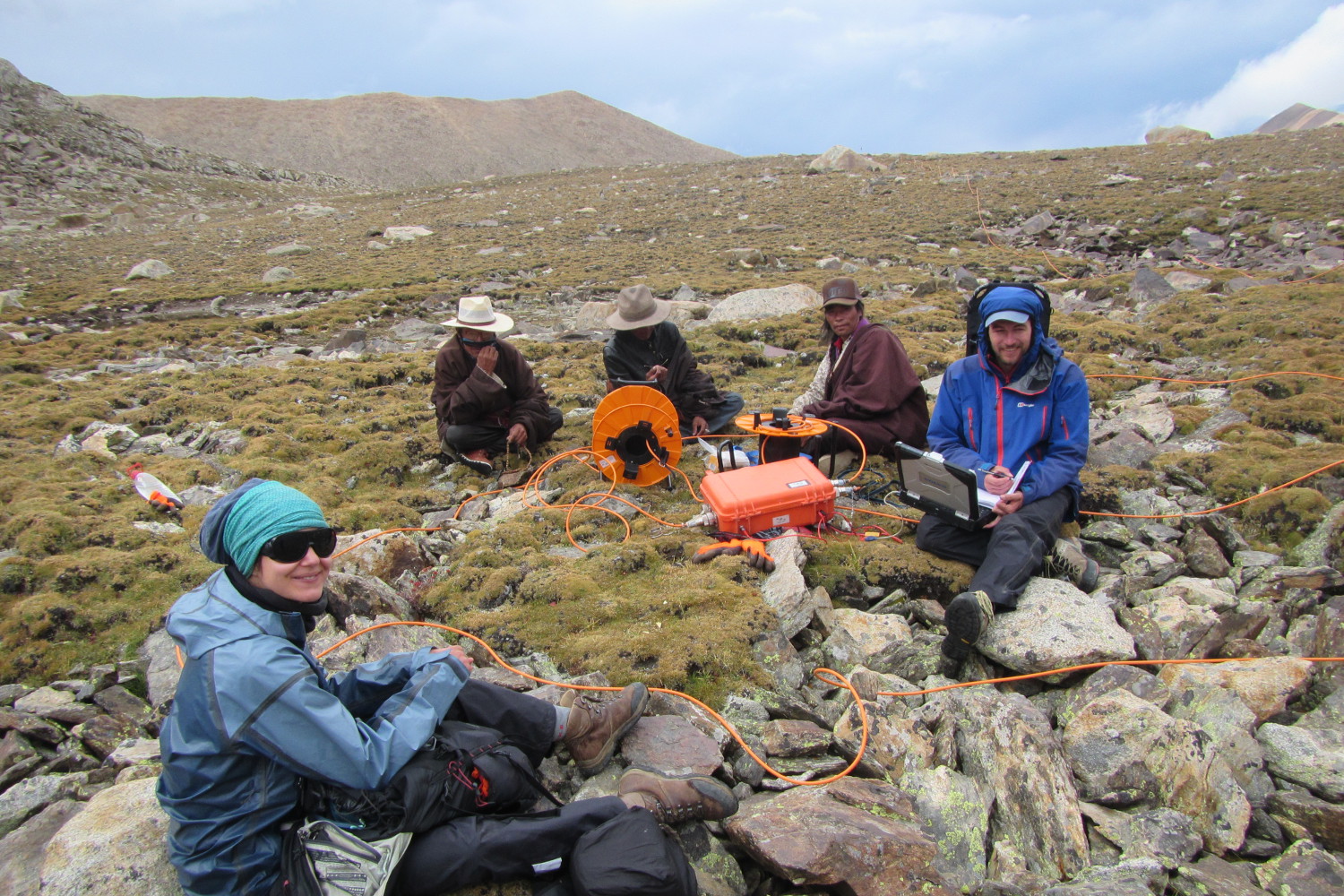
PhD student Johannes Buckel and master student Nora Krebs take geophysical measurements to detect ice in the ground. The work is being followed with interest by the Tibetans living in the area. Picture credits: Anne Voigtländer/GFZ Potsdam
Hard work far away from civilization
But the glacier landscape by no means reveals its secrets frankly: even the smallest bit of information can only be obtained through hard, exhausting work. The air at over 5,500 metres is even poorer in oxygen than at Nam Co. After every second step – often with heavy luggage full of measuring equipment – you want to take a breather. Often the body is already exhausted after several hours of ascent from the camp to the measuring area. The actual measurements take the the last of your strength before you drag yourself down into the valley in the late afternoon as if in a trance.
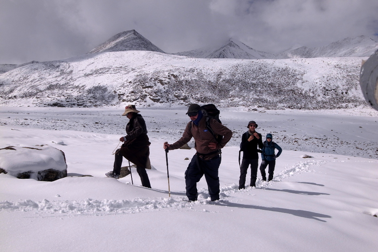
At the end of the field campaign, the study area turned into an icy winter landscape. If one only knew where the geophones were installed yesterday? Picture credits: Philipp Maurischat/Leibniz Universität Hannover
A few days before the end of the measurement campaign, there was a special highlight: the onset of winter. Within a few hours, up to half a metre of snow fell, covering the entire landscape, tents and measuring equipment. Now it was time to find equipment and dig it out, and then quickly ascend from the mountain. By now, the last doctoral students are on their way back to Germany. The fieldwork was successful and a lot of data was collected. Now it’s back to the office: Let the evaluations begin!
And so we say goodbye to China for this year. But we know: We’ll be back.”
Text: Dr. Matthias Bücker, Johannes Buckel, Dr. Nicole Börner, Kim J. Krahn, Alexandra Müller